The night before we left Durban I couldn’t sleep. We were driving to Lesotho the next day through the SaniPass – one of the most renowned mountain passes in South Africa. And also a 4×4 track. If you’ve read previous blog posts (particularly the ones in Namibia) you will know that we weren’t able to rent a 4×4, but instead we have a 4×2 with high clearance and other features like ‘diff lock’ (I had no idea what that meant before we started this road trip!).
Anyway, I’d spent the afternoon reading forums about driving the pass and whether or not it was doable in a 4×2 and it left me feeling confused and anxious. Some said it could be done in a compact car in good weather, others promised a death sentence unless you had a proper 4wd vehicle. James was convinced we’d be totally ok, especially if the weather and conditions were good (which they were supposed to be) and assured me that the worst case scenario would be that we start our way up, decide it’s too much and turn back around (whereas I was picturing the worst case being us rolling down the cliff to our deaths…perhaps I was being a tad dramatic?).
Anyway, we set off from Durban and I tried to keep my anxiety at bay during the 2.5 hour drive before the Sani Pass turnoff. James was feeling guilty and said that we didn’t have to go through with it but I said we should press on.
We reached the turn off to the dirt road and it started to get a little bumpy. It was about 25kms to the South African border crossing, where they can technically turn you away for not having a 4wd. The guy barely asked to see our passports, let alone wanting information about the type of car we planned to take to the top of the pass! We got back in the car and geared up for the last 8kms to the Lesotho border crossing. So far, it wasn’t nearly as bad as half the roads we drove in Namibia! My nerves were certainly calmer.
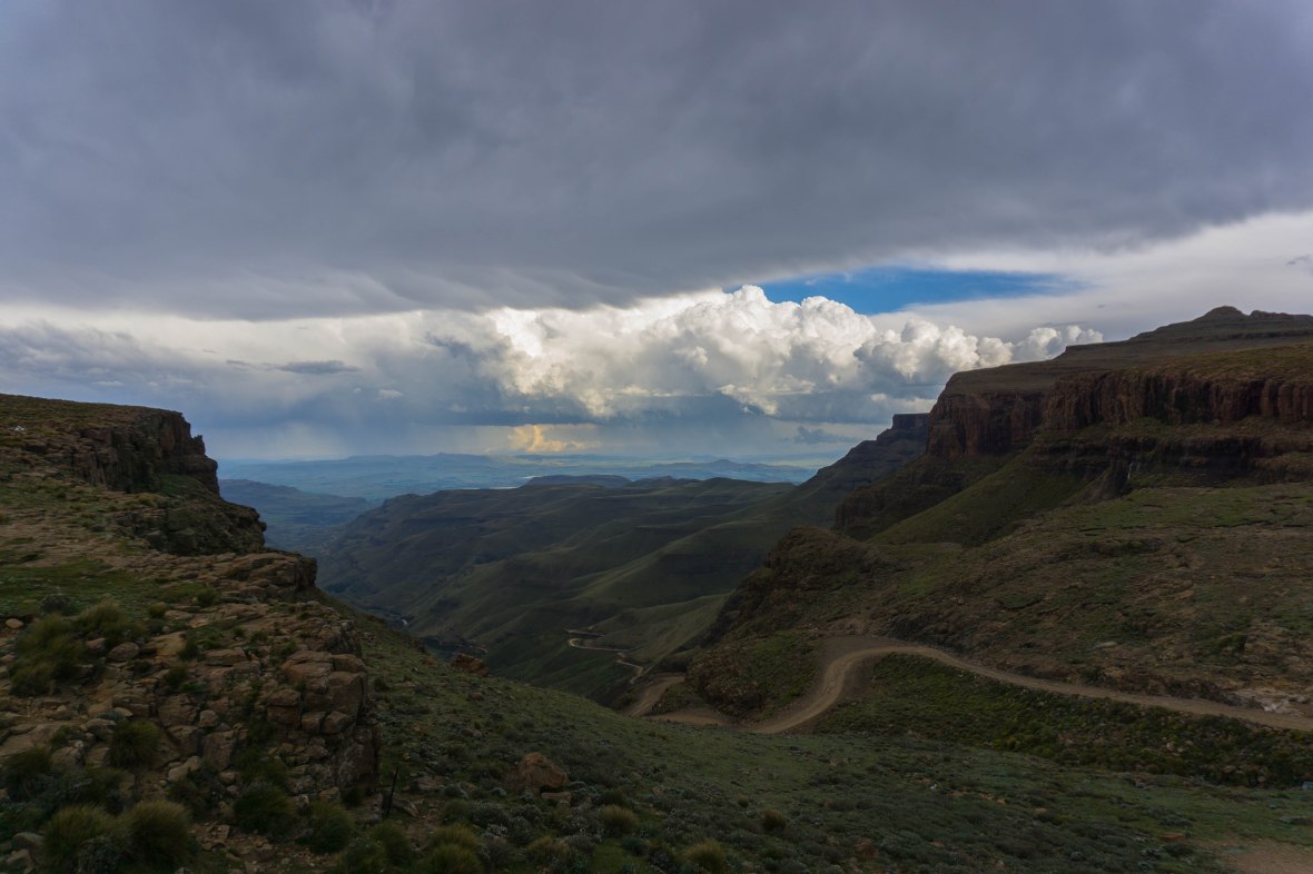
The last bit was definitely steeper, driving over large rocks and trying to look out for potholes and it wasn’t long before we were at the infamous ‘switchbacks’. This is the part of the pass many describe as the most dangerous, as it is steep and there are 6 sharp turns as you zig zag up to the top. A few years ago, the bends were widened and we made it up without an issue! We did have ideal, dry conditions and I can see how it would be more treacherous in wet or snowy weather!
If you don’t get motion sickness, here is a (sped-up) video of the last part of the drive:
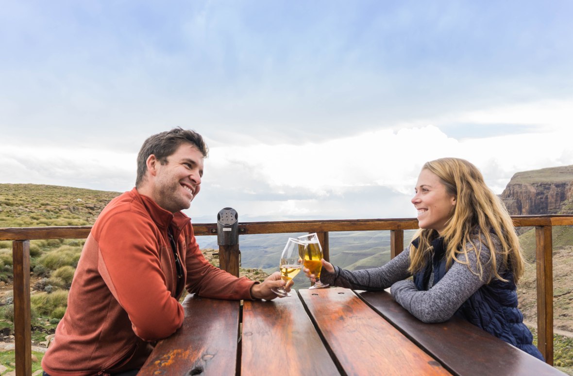
After making it through the border crossing we made the obvious stop at Sani Mountain Lodge, home of Africa’s Highest Pub for a celebratory beer and a few photos.

We were staying at Sani Stone Lodge, a few kms down the road. We made the turnoff for Sani Stone Lodge from the main road and joked that it was in worse condition than the pass! We hadn’t booked ahead, but I did verify that they had availability a few days before we arrived. We were taken to the double room with en suite and told there was one with a heater (of two) so we took that one. There wasn’t any electricity and the heater had a giant propane tank beside it. On each of our bedside tables stood a gas lantern. And let me tell you – it was COLD! We got the heater going and put on every piece of clothing we had before heading next door to the backpackers and use the kitchen for dinner. The backpackers was strange – the dorm beds and the kitchen were all one room and as we cooked our steak I couldn’t help but thinking how annoyed I’d be if my bedding smelled like whatever other people were cooking. Luckily, no one was staying at the backpackers.
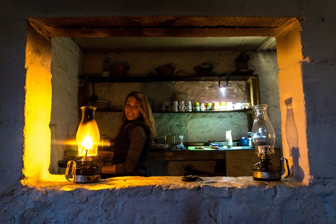
We got back to our room to discover that our heater had turned off and it appeared the propane tank was out. James went over to the main building only to be told that there weren’t any extra tanks. We had seen one hooked up outside the backpackers and James spent a good half hour switching them out and trying to get the heater going again, which unfortunately also meant letting the gas run. I was starting to think sleeping here would end up being more dangerous than driving the pass! After heating up our room we decided it was in our best interest to turn off the heater for the night and avoid a gas leak. Thankfully the beds were equipped with about 10 layers of blankets so I fell asleep feeling like the Princess and the Pea.
The next morning I woke up with a terrible headache and feeling nauseous. I thought back to the night before and figured since I’d only had 1 glass of wine with dinner, there’s no way it could be a hangover. It was cold and rainy outside and so we decided to skip the hike we were planning, and drive through the country and back out into South Africa – heading toward Royal Natal National Park.
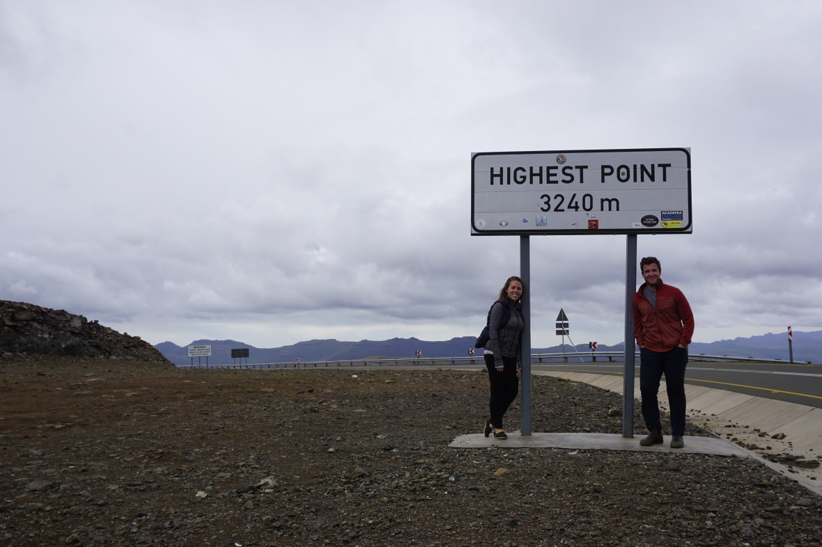
The drive through Lesotho was interesting – it was completely isolated in parts and it felt like we were the only ones around (apart from the trio of old guys on their motorcycles who were doing the same route as us that we kept running into). Every once in awhile we would pass a flock of sheep being herded by a Basotho shephard – keeping warm with a traditional woolen blanket wrapped around him and a balaclava. The drive was windy, through mountain passes. I was still feeling ill and James started sharing some of the ‘fun facts’ he’d read about Lesotho, including that it is the highest country in the world – the entire country is above 1000m. It dawned on both of us that I was probably suffering from very mild altitude sickness – something that I’ve experienced in the past in places like Machu Picchu. We did go from sea level in Durban to over 3000m ASL in a matter of hours after all! In any case, by the time we exited Lesotho I was feeling better, but still not 100%.
We had planned to drive to Royal Natal National Park where we would be camping for the next few days, but since the weather was less than ideal (cold and rainy) we opted to stop in Clarens, which ended up being a great stopover! We stayed at Highland Quarters in a massive hotel room (by our standards after living in a tent!) with a super comfy bed complete with heated blankets. It was exactly what I needed to get back on my feet again!
The next morning, we grabbed coffees from one of the local cafes and walked around the town browsing the shops. We came across a gin distillery called Red Stone Craft, so naturally had to try that (but only after we’d finished our coffees and it seemed appropriate to consume alcohol). We tasted their gin, along with several others from the area and they were all pretty great but we liked theirs the best. They use cider from the micro brewery next door as the base for their gin, so it ends up being super smooth. We picked up two small bottles to enjoy over the coming weeks.
After having some lunch, we continued on our way to Royal Natal National Park and the surrounding Drakensberg mountain range. We set up camp and had a relaxing afternoon until we started cooking dinner as a thunder storm rolled in. We turned in early (there’s not much choice when you’re camping in the middle of a storm!) once again impressed with how well our little tent was holding up.
The next morning the skies were clear and after breakfast we decided to go on a hike – the real reason we were staying here! I had read about this great 14km hike to the top of the Ampitheatre that provided stunning views of Tugela Falls. I had read it was a pretty easy hike, with a gradual climb. There was a lot of conflicting information, but it seemed clear that you left from the parking lot and took a path along the river – it was sign posted so hard to get lost. But what I didn’t read was specifically which parking lot to leave from, and so we took the only path we could see from our campsite (which connected to the parking lot for day visitors) and started out beside a river. That must be it right?! There weren’t any signs, but we figured as we continued it would become clear. We hiked past the cascades, where groups of people were swimming in the crystal clear pools. We saw signs for Tiger Falls which was seemingly the only path around and followed that. It was here, about an hour in that we started to think maybe we weren’t on the right path. But we continued on. We also saw another couple in front of us with a map and figured at least if we followed them we couldn’t get lost.
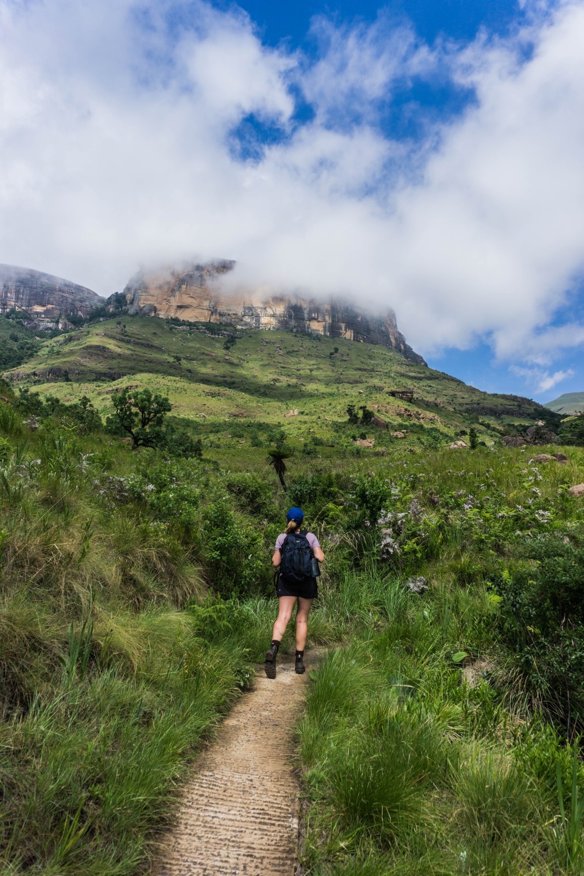
Soon, the path kind of disappeared and we found ourselves at a creek. We scrambled across from rocks to the other side and came up in a field of tall grass (it was during this part of the hike I remembered reading that there are poisonous snakes in the area). We made it through the tall grass to another pathway and saw some signs up ahead. At this point, we were two hours into the hike and had no idea where we were going. But it was a beautiful day, and we knew that we would more or less just have to climb straight up to get the views we were after. Though the signs did not give directions for either the amphitheater nor the falls, I did recognize ‘Gudu Falls’ and ‘The Crack’ and we decided to head in that direction. As we climbed stone steps that were 2 feet high (not super conducive to my 5’1″ stature) it was clear this wasn’t going to be the leisurely hike I had promised James.
We eventually reached ‘the crack’ which literally was a crack in the rock, where we climbed up rocks and ladders as we slowly made our way to the top.
And just when we thought we were there – more climbing! But it was totally worth it as the views were fantastic. We had a snack and some water before taking the drone out for a quick spin and then continuing on our way.

Next we headed over to Ploughman’s Kop – or at least we wandered around trying to figure out where and what Ploughman’s Kop was. All we knew is that we needed to take ‘the mudslide’ (which is described as not suitable for children or those with a fear of heights) and there may be some chain ropes to help us make our way down.
We did eventually see a chain and figured in lieu of any signage, it was probably the right way. It wasn’t particularly scary, though there were certain parts where it was tricky to find your footing. In the video below, James is filming me on one of the chain ropes and I basically tell him to stop f&*#ing filming and help me (due to embarrassment, I’ve cut that part out! ;P). But happy to say we both made it out of there unscathed.
Sorry ‘viewers’ for not speeding it up 😉 At least I cut the remaining 30s of me climbing down that chain rope, right?!
Once we had more or less finished our descent, it was a relatively flat walk back to camp. We were exhausted, ready for a shower and also about 5L of water each (since the hike was supposed to be relatively easy we’d only brought one liter each).
After the fact, I found this little website which details all the hikes. We basically combined 8, 11 and 14 which I’m guessing is around 15-16 kms total. We took it pretty easy the rest of the afternoon 🙂
We had planned to stay in Royal Natal one more night and get another hike in, but unfortunately mother nature had other plans and the next day had 100% chance of showers all day. We instead decided to drive in the rain to Johannesburg a day early – we were picking my best friend Lindsay up in two days to head into Kruger with her and her husband!
Both the SaniPass and the Drakensberg were incredible, and we only saw the northern Drakensberg! For hikers, spending a week checking out the different areas would be paradise. And for drivers, the SaniPass is remarkable. Just make sure you do some research before you decide to drive 😉
-Catie xx

There are plans to tar the Sani Pass road in the near future – a pity really but I suppose that will make it more accessible.
LikeLike
Yes we read about that too! Will be strange to come back in 10 years and see how it’s changed (if they do go ahead with it)
LikeLiked by 1 person
Beautiful pictures !!
LikeLike